


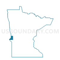
Redpath Twp. Voting District, Traverse County, Minnesota
About
Outline

Summary
| Unique Area Identifier | 604667 |
| Name | Redpath Twp. Voting District |
| County | Traverse County |
| State | Minnesota |
| Area (square miles) | 38.92 |
| Land Area (square miles) | 38.92 |
| Water Area (square miles) | 0.00 |
| % of Land Area | 100.00 |
| % of Water Area | 0.00 |
| Latitude of the Internal Point | 45.89054050 |
| Longtitude of the Internal Point | -96.32035710 |
Maps


Graphs
Select a template below for downloading or customizing gragh for Redpath Twp. Voting District, Traverse County, Minnesota


Neighbors
Neighoring Voting District (by Name) Neighboring Voting District on the Map
- Clifton Twp. Voting District, Traverse County, MN
- Gorton Twp. Voting District, Grant County, MN
- Lake Valley Twp. Voting District, Traverse County, MN
- Logan Twp. Voting District, Grant County, MN
- Monson Twp. Voting District, Traverse County, MN
- North Ottawa Twp. Voting District, Grant County, MN
- Tintah Twp. Voting District, Traverse County, MN
Top 10 Neighboring County Subdivision (by Population) Neighboring County Subdivision on the Map
- Lake Valley township, Traverse County, MN (237)
- Monson township, Traverse County, MN (133)
- Logan township, Grant County, MN (93)
- Clifton township, Traverse County, MN (75)
- North Ottawa township, Grant County, MN (50)
- Gorton township, Grant County, MN (49)
- Redpath township, Traverse County, MN (48)
- Tintah township, Traverse County, MN (33)
Top 10 Neighboring Unified School District (by Population) Neighboring Unified School District on the Map
- Wheaton Area School Public School District, MN (2,186)
- Herman-Norcross School District, MN (993)
- Campbell-Tintah Public School District, MN (755)